 Actual Adventure Pvt. Ltd.
Airpots in Nepal
Bharatpur Airport
The airport is located 1 mile (1.6 km) southwest of Bharatpu. It is operated by the Civil Aviation Authority of Nepal (CAAN) and is served by Nepal Airlines, the national airline which earns most of its revenue from this airport.
Bharatpur Airport is the country's 4th busiest. It is the main tourist gateway to Chitwan National Park, and is growing fast in terms of aircraft and passenger traffic: the trend for five years shows a steady growth of aircraft and passenger movements. The data up to November 2005 shows a growth of 7.5% and 17.6% against figures in the year 2004
This airport was built as part of the resettlement and malaria control program in the Chitwan valley, with the assistance of the Government of the United States of America. The first passenger carrying flight landed in the airport on 5 March 1965The airport was initially served by domestic flights with grass runway from Tribhuvan International Airport, Kathmandu and Pokhara Airport in Pokhara by the country's national airline Nepal Airlines. After many years of lobbying by the local people and expatriates living abroad, limited expansion of the airport was carried out; a new terminal was built and the 1158-metre runway was paved to enable medium-sized aircraft used by Nepal Airlince and Nicon Air to operate. The work was completed in October 2005.
Airport Fact Information
- Airport Code: BHR
- Airport Name: Bharatpur Airport
- Runway Length: 3800 ft.
- Runway Elevation: 600 ft.
- City: Bharatpur
- Country: Nepal
- Country Abbrev: NP
- Airport Guide: Unavailable
- Longitude : 84° 25’ 0” E
- Latitude: 27° 41’ 0” N
- World Area Code: 755
- GMT Offset: +5.4 Bharatpur Airport
Gautam Buddha Airport
Gautam Buddha Airport also known as Bhairahawa Airport, is an airport serving Bhairahawa, a municipality of the Rupandehi district in the Lumbini zone in Nepal.
The airport resides at an elevation of 358 feet (109 m) above mean sea level. It has one runway designated 10/28 with an asphalt surface measuring 1,510 by 34 metres (4,954 × 112 ft).
Bhairahawa is entrance point for Lumbini tour, It is only one direct connection with Kathmandu to visit the world heritage site Lumbini.
Agni Air , Buddha Air, Gorkha Airlines , Guna Airlines ,Yeti Airlines are running their flights to Bhairahawa from Kathmandu.
Jomsom Airport
Airlines and destinations
- Agni Air (Pokhara)
- Nepal Airlines (Pokhara)
- Sita Air (Kathmandu, Pokhara)
- Tara Air (Pokhara)
Location
- City: Jomsom, Nepal
- ICAO / IATA: VNJS / JMO
- Type: STOLport
- Use: Public/Civil
- Latitude: 28°46'56"N (28.782222)
- Longitude: 83°43'21"E (83.722500)
- Elevation: 8800 ft (2682 m)
- Runways: 1
- Longest: 2001 × 98 ft (610 × 30 m)
- Time Zone: UTC+5:45 (DST+5:45
Related Locations
- Nearby: Nepal (NP)
- Farthest: IPC: 11635 mi / 18725 km
- Airport type: Public
- Serves: Jomsom, Nepal
- Elevation AMSL: 8,800 ft / 2,682 m
- Coordinates: 28°46′56″N 83°43′21″E / 28.78222°N 83.7225°E / 28.78222; 83.7225
- Runways Direction: Length Surfacem ft 06/24 531 1742 Asphalt
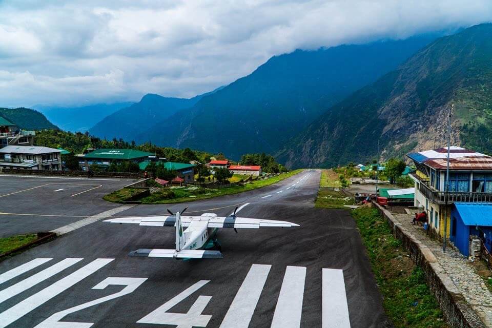
Lukla Airport (Tenzing-Hillary Airport)
Tenzing-Hillary Airport also known as Lukla Airport, is a small airport in the town of Lukla, in Khumbu, Solukhumbu district, Sagarmatha zone, eastern Nepal. The airport was renamed as Tenzing-Hillary Airport in January 2008 in honor of Sir Edmund Hillary and Sherpa Tenzing Norgay, the first persons to reach the summit of Mount Everest and also to mark their efforts in the construction of this airport. The surrounding terrain, thin air, highly changeable weather and the airport's short, sloping runway make it one of the most challenging landings in the world. The History Channel program Most Extreme Airports ranked it as the most dangerous airport in the world.
The airport is popular since Lukla is the place where most people start their climb of Mount Everest. There are daily flights between Lukla and Kathmandu during daylight hours with good weather. Although the flying distance is short, it can easily be raining in Lukla while the sun is shining brightly in Kathmandu. High Winds, cloud cover and changing visibility often mean flights can be delayed or the airport closed completely. The airport is contained within a chain link fence and patrolled by the Nepal armed police or civil police around the clock
Phaplu Airport
Phaphlu is a mountainous town in north-east Nepal, approximately 90 kilometres east of the Nepalese capital, Kathmandu.The airport resides at an elevation of 7,918 feet (2,413 m) above mean sea level. It has one runway which is 671 metres (2,201 ft) in length.[1] The Civil Aviation Authority of Nepal has been carrying on it's reconstruction and improvement work of Phaplu terminal building.
Airlines and destinations
Airlines Destinations
- Nepal Airlines: Kathmandu, Lukla
- Tara Air: Kathmandu
Airport Codes
- Flight Stats Code: PPL
- IATA Code: PPL
Fact information
- Airport type: Public
- Serves: Phaplu, Nepal
- Elevation: AMSL 7,918 ft / 2,413 m
- Coordinates: 27°31′05″N 086°35′04″E / 27.51806°N 86.58444°E / 27.51806; 86.58444
- Runways Direction Length Surface m ft 671 2,201
Pokhara Airport
Pokhara Airport is a One of the popular Airport in Nepal. it code name is (IATA: PKR, ICAO: VNPK), is a regional airport serving Pokhara in Nepal. The airport was established July 4, 1958 AD and is operated by the government (Civil Aviation Authority of Nepal). It offers regular connections to Kathmandu, Jomsom and seasonal connections to Manang District. Following a new agreement on air travel between India and Nepal .it is currently being developed into Nepal's second international airport but not sure yet.. In 2011 Buddha Air, a Nepali private airline will begin international flights from Pokhara to Lucknow adding New Delhi in the future. Pokhara airport is main Entrance point for Trekking in Annapurna , mustang and Dhaulagiri region.